AMERSHAM (Metropolitan Line) LONDON TUBE RAMBLES An unspoilt market town full of half-timbered and Georgian buildings set in beautiful countryside 3 miles


 Soon you will see the first of many small black and white buildings – Three Gables - originally a 17th century outhouse. Turn left into Rectory Hill, which becomes Church Street. The large buildings near the church were part of a brewery, now converted into flats. This brewery, owned by the Weller family, was once the biggest employer in Amersham and has an interesting history which can be read here.
The house opposite
has a Georgian facade, while its next door neighbour is in 'Gothick' style. Amersham is
full of 17th and 18th century houses, with even older ones hidden behind later brick walls or tucked away in side streets. When you reach Market Square turn left. A few doors along is the Old Grammer School.
Retrace your steps and cross Church Street carefully (it’s an awkward corner) to see the imposing Market Hall which was built for the town in 1682 by the Drake family. Amersham obtained a charter for a market and annual fair in 1200. Although the market no longer exists in its original form, the fair is still held in September – a remarkable unbroken tradition.The old town Lock-up can be seen in one of the north-east arches of the hall, with the old Parish Pump (dated 1785) nearby. As you go into the narrow Market Walk you can see a plaque from which you will learn that the town has a long history of nonconformity. In 1931 a memorial was erected to honour those who were martyred for their beliefs.
Go past the Market Hall for a view of the High Street, You will notice a discrepancy in the type of buildings on the north and south sides of the road. The clue as to why this happened is the River Misbourne which runs along the back of the properties on the south side. This led to the area being used by trades of all sorts. It was also liable to flooding, but in recent times the problem has been the reverse, the river drying out completely for several years owing to water extraction from bore holes. Although work has been done to rectify, this the river still gets low in time of drought.

Something else that might strike you is the great number of inns. This is because Amersham was once a coaching town on the road from the Midlands to London - several hostelries have archways large enough for coaches to pass through. The most flamboyant of these is the King’s Head. However, although it looks old, the frontage is mostly ‘Brewers’ Tudor’ created in the twentieth century by the skilful re-use of ancient beams. Happily, inside there is still much that is original. Incidentally, If any of the inns seems vaguely familiar, it might be because some scenes in Four Weddings and a Funeral were shot in the town.

 Now it is time to explore the north side of the High Street. Don’t miss such gems as The Gables at No. 27 with the trunk of an old wisteria creeping out into the street, or the smallest house in the town, No.129 (16th century). Red Lion House (No.41) was once an inn and the town Museum (see footnote) is close by. Finally there is Turpins Row, a long run of late 16th century cottage - named after a builder, not the highwayman. Just beyond these is Town Mill on the Misbourne. A mill on this site was mentioned in the Domesday Book survey of 1086. In its working life it was used to make paper and to grind corn. Now a private residence.
 Cross over to the other side of the road for grander buildings. No. 132, Hinton House, is unadorned red brick Georgian, set well back from the street. Walk a little way back in the direction of the Market Hall for the snug Drakes Almshouses (1657) built to provide homes for six needy widows of the parish. ’The Worthies’ at Nos. 54/56 has its strange name emblazoned in large letters across an coach archway and is so called because inside there are wall paintings (c.1550) of the Nine Worthies. Records show that in 1700 it was The White Hart inn. Elmodesham House, a large, rather daunting, brick building (Georgian but with a 20th century frontage), was once a school, then Council offices. Now is has reverted to its original use as domestic housing, this time as apartments. Next door but one is the King’s Head, then the elegant Apsley House (early 18th century) - a contrast to its neighbour, The Old Forge, a 16th century timber-framed building. Continue up the High Street to get to the Crown Hotel (16th century, but rebuilt in the nineteenth).
 Return to Whielden Street. I blinked at the date on the '1372' sundial at No. 19 - it clearly has nothing to do with the present building which is late16th century. Nos. 22-28 was a Georgian workhouse (in those times the poor were not accommodated in single large instutitions) whose inmates were set to making lace and spinning. Lace was also made in several other houses in the street. Black lace, for which Amersham was famous, was made at Nos. 44-46. You can see samples of it in the museum. Walk as far as Amersham Hospital, originally designed as a workhouse, in the gothic style beloved by George Gilbert Scott. Dated 1838, it remained in use as a place to house the indigent until 1930 when it became a hospital, though part of it was still a ‘Public Assistance’ institution – workhouses did not disappear altogether until the National Assistance Act of 1948. Those interested in workhouse history will find more details of Scott’s 40 or so workhouses here.Turn round and walk down the west side of Whielden Street. The Quaker Meeting House is a comfortable sort of building, converted from a barn in the late 17th century. It was the home of the wife of William Penn (Quaker founder of Pennsylvania). On the corner of The Platt, No. 45 was a furniture factory , and No. 43 on the other side a bakery.
 Turn into the alleyway. Here you will find a number of small 17th century half-timbered buildings, clustered higgledy-piggledy – including the endearingly quirky Chimney Cottage. At the end of the lane is a cemetery reserved for residents of Old Amersham – a lovely site on the rolling Chiltern hills. Retrace your steps to find the path (Chapel Yard) that leads to the late 18th century King’s Church which has an amazing lantern roof. It was formerly a chapel for the Particular Baptists. From the plaque on the side of the chapel you will learn that a British School was established here in 1842. The large building at the end of the path was a warehouse. To the right you can see the rear of the King’s Head.
When you regain the High Street, cross and turn right. Go over Church Street with care and continue to St. Mary’s Church. The earliest parts of the building, nave and transepts date back to the 13th century. Like most other parish churches it has been added to and altered over the centuries. Oddly, in a town where conservation is generally of a high standard, St. Mary’s has been changed in ways that have removed some of its character, notably the installation of a modern floor. However, if monuments are your thing the church is worth a visit. It’s usually open during the day but you might need to get the Drake Chapel key from the Rectory (contact details on the church website).
If you are staying in the Chilterns area you might be interested in this list of walks which contains routes that are suitable for those who love to spend a whole day rambling around the countryside.
1) Market Hall
2) Three Gables
3) Houses in Church Street
4) Turpin Cottages
5) The King's Head
6) Town Mill
7) Hinton House 8) Drake Almshouses
9) Whielden Street, looking north towards Rectory Hill
10) Outhouse, The Platt
11) Chimney Cottage
12) King's Church
13) St.Mary's Parish Church
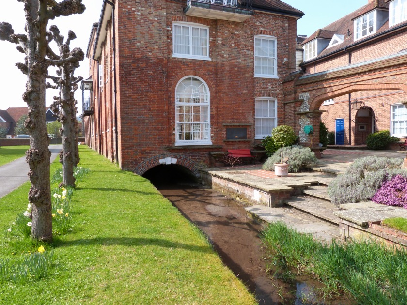
14) Misbourne flowing under old brewery.
Details of many of the buildings mentioned above can be found on the Amersham website. There’s even more to discover at the charming small museum, housed in an ancient building at No. 49 High Street, once part of a medieval hall house. (Please note that there is an entrance charge and the museum is closed during the winter months.)
*The lower track is an even better walk, as it is further away from the traffic of Rectory Hill, but it does take about five minutes longer.. If you wish to take this route, simply follow the track round to the right as it skirts the field until you join the upper path at the edge of the woods, where there is a seat and Public Footpath sign. Although both these paths are passable even after heavy rain, I’m afraid they are not really suitable for buggies etc. as there are a lot of flints on the surface in the woodland area which would make for an uncomfortable ride! Station Road does lead to the town, but the walk takes about twenty minutes.
MAP
This is just one walk from the many to be found at London Tube Rambles. There are architectural gems, beautiful country views, historic places and quirky buildings in the area covered by the outer London Underground stations. Usually the discoveries are within a mile of the Tube - often only five minutes walk away. If you reached this as an individual page via a search engine, you might like to go to www.londontuberambles.co.uk to see the other destinations explored. You'll be amazed at what's out there!
©DR
©DR